
|
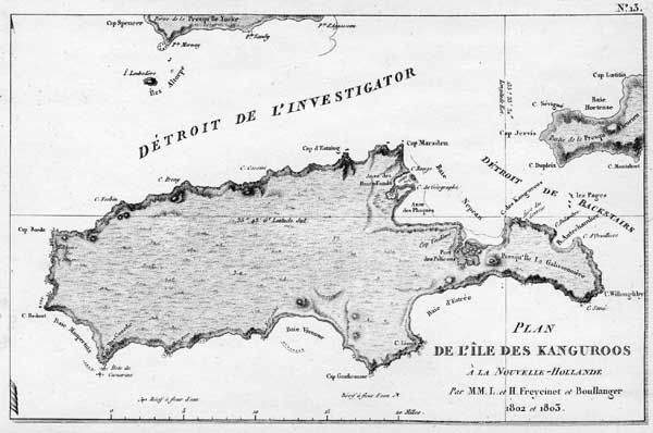
Freycinet, Louis de. Voyage de decouvertes aux terres : Atlas historique, Part 2. (1824) - Plate no. 13, [part 1]. 'Plan de l'ile des Kanguroos : a la Nouvelle-Hollande'.Part of Plate no. 13. Freycinet, Louis de & Henri-Louis, and Boullanger, Charles-Pierre. Plan de l'ile des Kanguroos : a la Nouvelle Hollande (1802 & 1803). Map of Kangaroo Island, South Australia with relief shown by hachures. This map is held in the published sheet map collection of the State Library. It is an unsourced publication probably from the second edition of Francois Peron's work on Baudin's voyage. This edition is not held by the State Library. When the second edition of Peron's publication of the Baudin expedition was published in 1824, the political climate in France had changed and, as well, Matthew Flinders' own charts had been published in 1814. Accordingly, the French finally acknowledged Flinders' prior discoveries along the South Australian coast, as evidenced with this map. Ile Descres has been renamed Ile des Kanguroos (Kangaroo Island), and Flinders' Antechamber Bay, Point Marsden, and Pelican Lagoon are shown, as well as Investigator Strait (Detroit de Investigator) and Backstairs Passage. To this day, Kangaroo Island's place names are testimony to both the French and English discoveries of the southern portion of South Australia's coast. Click here for catalogue information on this item.
A copy of this item may be made for private use, but further publication requires the permission of The State Library of South Australia. |


